|
StormPursuit
Forecast Tools:
Pictures/Accounts:
Education:
The Rest:
|

|
2002 Chase Accounts |
|
April 29th 2002 Today was
interesting, a moderate risk was issued early in the day, so
I expected a little bit of action towards the evening hours.
I was just finishing class and noticed that we had a storm,
fairly strong, coming in from our west. I got out of class
which was at Frankford and Marsh then quickly took some
stills and rushed north. While heading north on marsh, I
noticed some rotation in the storm. I tried calling it in,
but unfortunately my ham radio wouldn't transmit due to
microphone failure. I got wind gusts near 40 miles an hour
and torrential rains. I expected flooding, and as usually
the bridge at Valley View and Marsh began to become overcome
by water. I stopped and helped police block off the bridge
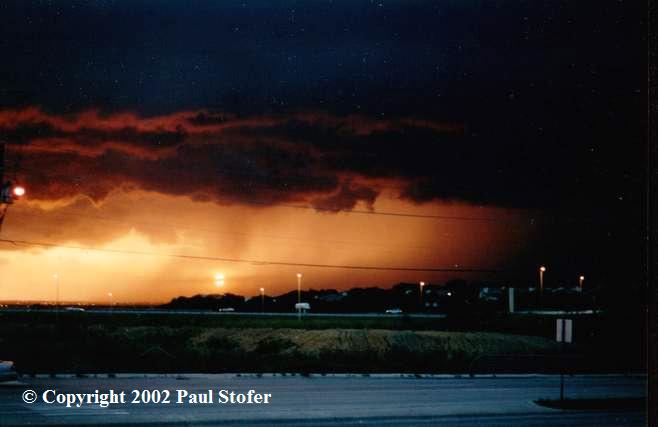
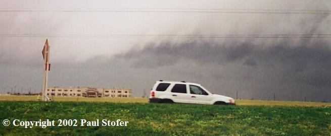
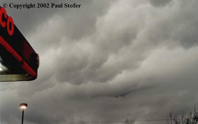
and ended my chase. June 16TH 2002 Today I chased a strong line of storms as a guest front moved through along a cold front. I knew there wouldn't be any rotation in the storm, but I was hoping to get some good lightning shots along with wind damage. The line moved in around 1:45AM and I went North on Marsh and turned into a parking lot at Frankford. I sat and faced the West as the line moved East and watched a great lightning show. Eventually I started clocking 30+ MPH wind speeds, even though the media and NWS expected 50-70MPH winds. Wood street blocks began tipping over and lots of transformers started blowing. It was a rather weak squall by the time it got to me, but I got some pretty cool green flashes on video! Sorry guys, no pictures with this one! October 6th, 2002 Around 4:00PM the National Weather Service had issued a Severe Thunderstorm Warning for Jack county. About 5PM the storm moved into Denton county and I chose to scope out the storm and see what was going on. My cousin wanted to tag along so he jumped in the car and we headed North. I didn't expect to see anything except for a little structure. We headed North on Marsh until we hit Rosemeade and I felt we should get a little further West of the storm so we headed West on Rosemeade. Once we were West of the storm, we headed North on Josey so we could be on the South-West side of the storm. At this time we were now in Denton County. I saw a downburst then something really interesting happened. We were sitting in a parking lot, I noticed a lot of dust getting kicked up, and then rotation! It wasn't a tornado, but a Gustnado! It was cool, much more than I expected for today! When the gustnado died out we headed East on Parker Road and then North a little bit until we hit Highway 121. From there we followed the storm until I felt the storm was over. We headed back South on the toll road with pictures of a gustnado and a story of a chase that wasn't thought to be a success! December 30th, 2002 I woke up around noon today and saw numerous cells North of me. The strongest were just Northwest of the Frisco area. I was watching NOAA TV here in Dallas and suddenly the Warning Tone goes off. THE NATIONAL WEATHER SERVICE IN FORT WORTH HAS ISSUED A TORNADO WARNING FOR THE FOLLOWING COUNTIES: COLLIN COUNTY IN TEXAS... A tornado warning was issued for Frisco in Collin!! I threw my clothes on and rushed to put the weather frame on my car. In a matter of 10 minutes I was out of the house and on the Toll road heading north. I exited 121 just in time to get slammed by outflow, the most amazing cloud formation I've seen. It was rolling over itself, it was almost spooky looking! At that time I was recording 30 mile an hour winds. Over the radio spotters were watching a developing wall cloud in the Allen area so I quickly made my way Eastward. When I approached the intersection of Spring Creek and Chase Oaks Drive (No Phun Intended), I began to get pelted with quarter to golfball sized hail! (Hail Report) I called 911 and let them know of the incoming hazard and reported the sighting to the National Weather Service. My radar began to go crazy! I "punched" the core of the storm not knowing whether I was in the cell with the indicated tornado or not. I finally made my way out of the hail and rain, and saw the very weak, poorly structured "wall cloud". I was somewhat far away so I couldn't see the rotation very well, but spotters on the radio said it was rotating. At this time the sirens in my area were going off, so I pulled over to take a few pictures. The storms were heading south and were falling apart rapidly, so as I pursued them I decided to head home. I figured the storms were becoming outflow dominant and that would be it, which it was. The chase day ended, and I went home and fell back asleep...
|