|
March and April,
2008
Chased several days
in March and April; however nothing significant was
observed. I will leave these days alone.
May 1st,
2008
I started today
sitting in Bartlesville, Oklahoma. I noticed storms firing
to my North in SE Kansas so I immediately shot North and
sat in Independence, Kansas. I observed several intense
storms with solid updrafts to my NW, but it appeared they
were in a "grunge-like" cluster with no real
means of getting good solid inflow except for the tail
end. I didn't lose hope on the storms, but did re-adjust
south when I notice storms firing along I35. I traveled
South on 75 and then West on US60 out of Bartlesville. I
then traveled South on highway 99 through Pawhuska and
observed a very intense storm to my SW, which was the
Osage storm. The storm had a healthy updraft with a very
well defined inflow tail. I continued south on 99 through
Wynona and into Hominy. At this time there was a large
tornado being reported in the Vicinity of Pawnee, Skedee,
and Blackburn. I waited in Hominy for the cell to get a
little closer to I20, then immediately shot West on I20
out of Hominy. I stopped at the intersection of County
Road 541 and I20 and observed a large wall cloud with
intense rotation to my SW. At 0150 I observed a tornado on
the ground just to my SW. This tornado lifted shortly
after my arrival but once again dropped and continued
moving to the NNE. I observed this cyclical activity for
about 15 minutes as the tornado would drop then lift. I
counted this at least 4 times. The updraft continued to
still appear strong; however, as the storm disappeared
into the distance a condensed funnel was no longer
present. I did observe a couple of power flashes, and then
it was over. I went back East on 20 then North on 99 to
catch back up with the storm, but it had decayed very
rapidly and lost the majority of its intensity. The
structure today was amazing, and the tornadoes were very
photogenic. A great first chase of the season.
Chase Video can be
found: HERE
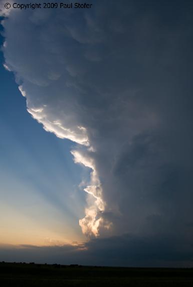
 Left
and Right: Pawnee and Osage County Tornadoes Left
and Right: Pawnee and Osage County Tornadoes
May 10th,
2008
Today I
started in Okmulgee, Oklahoma around 4pm watching Cu build
and die under the cap. About this time the dryline began to
race east so I went against my better judgment and went
south and east into the woods of SE Oklahoma. Towers began
to form just North of I40 around McAlester. I took I40 to
stay ahead of the storms as they made their way East. With
the dew points as high as they were (I was observing 70F at
my location), the haze made it difficult to see any storm
structure. There were 3 tornado warned storms at the time,
and I chose to play the middle storm, which passed through
the town of Yanush. I continued on I40 to highway 59 South
through Panama, Poteau, Heavener, and stopped at the
intersection of 270/59. At this time I placed myself between
the middle and southern storm. This location was a fairly
decent spot to observe the storm from the East, but
obviously not the best. I was confident I had placed myself
in a good location in between the two storms; however, with
screaming HP beasts in the woods of SE Oklahoma, falling
debris and no data I questioned myself. The storm to my
North had mild rotation, while the one to the South was
still looking fairly decent. I was south of the rotation to
my North, and North of the heavy precipitation to my south.
I observed a rather weak, wind and rain storm before it
passed. Apparently the falling debris was from a large
tornado near Yanush which had lifted. This was at one time
part of the storm to my North. I'm assuming the storm was
strong enough to carry this debris in it's updraft for quite
a ways. I made my way back West on OK88 through the National
Forest and observed the storms as they flew east from a
beautiful lookout over the forest. I continued back towards
Tulsa, and passed through both Yanush and the small town of
Arpelar to get damage video for Fox. Both of these towns had
fairly decent tornado damage. Today proved once again, why I
don’t like chasing in SE Oklahoma. I observed some nice
structure though the haze, and that was about it. My
thoughts go out to the folks effected by todays storms,
especially those in Picher, Ok where many people lost
their lives. Today was the deadliest tornado day in Oklahoma
history since May 3rd, 1999. Later in the week Fox sent me
up in the Helicopter to get damage video and photos of
Picher, Oklahoma.
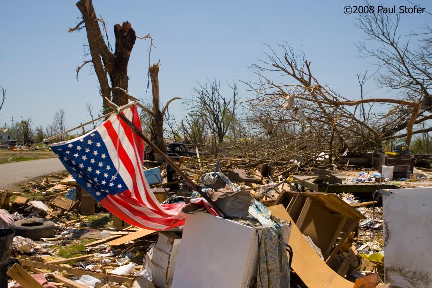  Left
and Right: Picher, Oklahoma Tornado Damage
Left
and Right: Picher, Oklahoma Tornado Damage
 Picher,
Oklahoma Tornado Damage
Picher,
Oklahoma Tornado Damage
May 13th,
2008
I
chased Southwest Oklahoma today. I ran into Amos Magliocco,
Bob Fritchie, Scott Eubanks, and Tim Carroll. Turkey towers
were observed, with agitated cumulus trying to break the
cap. Today was a cap bust and nothing significant was
observed.
June 4th,
2008
Today Dave Fick, Tim
Carroll, and myself chased Kansas / Nebraska. We initially
targeted a storm near Kearney, Nebraska. We followed
this storm to the NE along US80 until it became an HP mess
and we ran into road construction problems. During the day
we passed the TIV multiple times as well as the ROTATE team
from OU. We flew South on 281 and then West on 73 and
observed a gorgeous rotating LP thunderstorm. This structure
was magnificent. We photographed this storm until dark
and the storm got swallowed up by the squall line then we
returned to Hastings to stay in Nebraska for the night.
About an hour after arriving in Hastings the squall line
arrived at our hotel. We jumped back in the vehicle and
parked underneath the hotel awning to watch the storm roll
through. Right before the storm hit, a cell embedded within
the line went tornado warned and approached our hotel.
Shortly after the warning went out, the tornado siren at our
hotel went off and almost blew our ears out, and probably
woke every resident up. Hotel staff and guests stood by the
windows and the door of the hotel to watch as our vehicle
got rocked by 58 mph (recorded) downburst winds and hail at
1:03AM. During this time we observed small trees snap in
half, as well as the roof of the hotel across the street
start to peel away. After the storm passed we observed much
damage through the area. The gutter from our hotel was
ripped off, as well as damage in the Home Depot across the
street. We called it a night and prepared for our chase the
following day around Wichita, Kansas.
June 5th,
2008
Dave
Fick, Tim Carroll and myself left Hastings for Wichita
Kansas today. We observed a tornado-warned HP supercell pass
through McConnell AFB. We saw a beautiful lightning storm as
well as some small hail and a mean squall line. Nothing
significant was observed. We returned to Tulsa and arrived
in Broken Arrow later in the evening. Luck would have it
that after we returned to my house, a tornadic thunderstorm
approached my home when the squall line approached. A
tornado warning was issued just SW of Broken Arrow moving to
the NE. We went into my back yard and as soon as the warning
was issued the sirens in my neighborhood went off. We
watched to the SW and observed power flashes approaching.
The power to the house went out and I immediately called the
TV station to do a live phone interview. The power flashes
got closer so we retreated back into the house. The tornado
passed just NW of my home, and I observed small amounts of
damage in the NW part of my subdivision the following day.
Other than this, nothing else significant was
observed. 
|
